
Direct answer: The littoral zone is the shallow, sunlit nearshore region of a lake or pond where enough light reaches the bottom for rooted aquatic plants to grow. It is the most biologically productive zone in any lake, supports nearly all sport-fish spawning and juvenile habitat, and is also where almost every invasive aquatic weed infestation begins.
Defining the Littoral Zone
Limnologists define the littoral zone as the depth range where photosynthetically active radiation (PAR) reaching the sediment surface is sufficient to support rooted submerged plant growth — typically where bottom irradiance is at least 1–4% of surface irradiance. In practice, the littoral boundary in a clear lake may extend to 4–8 meters depth; in turbid or eutrophic lakes, it may be restricted to less than 1 meter. The relationship between light attenuation and plant colonization depth is the single best predictor of where weed beds will establish in a given water body.
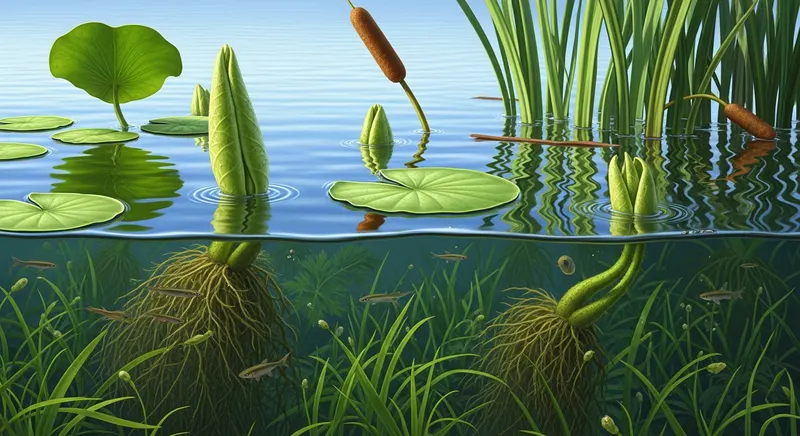
The zone is structurally divided into three sub-bands: the eulittoral (the wave-washed band at the waterline), the infralittoral (the rooted submerged plant band below mean low water), and the supralittoral (the periodically wetted splash zone). Emergent species such as cattails and bulrush dominate the eulittoral; floating-leaved plants like water lilies bridge the boundary; and submerged species including Eurasian watermilfoil, hydrilla, and native pondweeds dominate the infralittoral.
Why the Littoral Zone Matters Ecologically
Per unit area, the littoral zone produces more biomass, supports more biodiversity, and processes more nutrients than the open-water (pelagic) zone. It is the dominant fish spawning and nursery habitat in almost every North American lake — bluegill, largemouth bass, northern pike, and yellow perch all rely on littoral plant beds for nesting, juvenile cover, and forage. Loss or degradation of littoral habitat — whether from shoreline development, sedimentation, or invasive plant monocultures — produces measurable declines in sport-fish populations within 3–10 years (see the fish and wildlife habitat impact guide).
The littoral zone is also the principal site of nutrient cycling between sediment and water column. Rooted submerged plants pump phosphorus from sediment porewater into their tissues, then release it back to the water column during fall senescence — a process tightly coupled with summer thermal stratification and fall lake turnover.
The Littoral Zone and Invasive Weeds
Nearly every invasive aquatic weed problem in U.S. lakes begins in the littoral zone, for three reasons: it provides the light and substrate that rooted invasives require; it concentrates the boat traffic and shoreline disturbance that introduce and spread propagules; and it captures the runoff-borne nutrients that drive the eutrophication process. Boat ramps, marina basins, and developed shorelines are predictably the first places hydrilla, Eurasian watermilfoil, and curly-leaf pondweed appear. Early-detection monitoring focused on these high-risk littoral areas — described in monitoring and survey methods — is the single highest-return investment for weed-free lakes in regions where invasives are established.
Management that ignores littoral ecology rarely succeeds. Whole-lake herbicide treatments that eliminate the entire submerged plant community — native plants included — predictably lead to re-invasion within 1–3 seasons, because the littoral zone abhors a vacuum and bare sediment is rapidly recolonized by whichever propagules arrive first. Best-practice integrated weed management programs preserve native littoral vegetation as a biotic resistance against re-invasion.
Healthy vs Degraded Littoral Zones
A healthy temperate-zone littoral zone supports 8–20 native submerged plant species, a complex three-dimensional canopy, native emergent vegetation along 60–90% of the shoreline, and minimal cover by any single species. A degraded littoral zone — diagnostic of established eutrophication, invasive dominance, or shoreline development — shows fewer than 5 native species, dense monoculture cover by hydrilla or milfoil, hardened or bare shorelines, and elevated sediment accumulation. The diagnostic transition typically occurs over 5–20 years following a triggering disturbance.
Frequently Asked Questions
How deep is the littoral zone?
In clear, oligotrophic lakes the littoral zone may extend to 6–8 meters depth, while in turbid or algae-rich eutrophic lakes it may be restricted to less than 1 meter. The functional boundary is the depth where bottom light is roughly 1% of surface irradiance — measurable by Secchi disk transparency multiplied by approximately 2 to 3.
Why do invasive weeds prefer the littoral zone?
Invasive submerged plants require both light at the sediment surface (only available in the littoral zone) and a substrate to root in. The littoral zone supplies both, while also concentrating the boat traffic, shoreline disturbance, and nutrient inputs that introduce and accelerate invasive establishment.
Is the littoral zone the same as the shoreline?
Not quite — the shoreline is the land–water interface, while the littoral zone extends from the shoreline outward to the depth at which light no longer reaches the bottom. The shoreline is at most a few meters wide; the littoral zone may extend tens to hundreds of meters offshore in lakes with gradually shelving bottoms.
Should I remove all littoral plants from my pond or lakefront?
No. Removing all littoral vegetation is one of the most counterproductive things a lakefront owner can do. Native littoral plants stabilize sediment, support fish habitat, take up nutrients that would otherwise feed algae, and competitively resist invasive species. Selective management targeting only invasive or genuinely problematic species — preserving native diversity — is best practice. See the prevention guide for shoreline plant recommendations.
What is the difference between the littoral and benthic zones?
The littoral zone is defined by light availability and supports rooted plants; the benthic zone refers to any lake or pond bottom regardless of depth. The deeper benthic zone (the profundal benthos) is dark, supports no rooted plants, and is dominated by microbial decomposition of organic matter falling from above.
How does shoreline development damage the littoral zone?
Hardened shorelines (seawalls, riprap, mowed lawns to water's edge) eliminate eulittoral plants and increase wave reflection that erodes adjacent sediment. Loss of overhanging vegetation reduces shade and woody debris that support fish. Lawn fertilizer runoff increases nutrient loading. Together these effects can degrade the littoral zone within a single decade of development.
References
- Wetzel, R.G. (2001). Limnology: Lake and River Ecosystems, 3rd ed. Academic Press, San Diego.
- Carpenter, S.R. & Lodge, D.M. (1986). Effects of submersed macrophytes on ecosystem processes. Aquatic Botany, 26, 341–370.
- Vadeboncoeur, Y., et al. (2002). Putting the lake back together: reintegrating benthic pathways into lake food web models. BioScience, 52(1), 44–54.
- Schindler, D.E. & Scheuerell, M.D. (2002). Habitat coupling in lake ecosystems. Oikos, 98, 177–189.
- Cooke, G.D., et al. (2005). Restoration and Management of Lakes and Reservoirs, 3rd ed. Taylor & Francis.
Ten-Year Lake Management Plan: Lake Wingra, WI
Lake Wingra, a 342-acre urban lake in Madison, WI, developed a comprehensive 10-year management plan coordinating the City of Madison, University of Wisconsin, and adjacent neighborhood associations. The plan addressed Eurasian watermilfoil, curly-leaf pondweed, and purple loosestrife through an integrated approach including targeted herbicide treatment, mechanical harvesting, native plant restoration, and public education.
Key outcome: The structured multi-agency planning process secured consistent funding across multiple budget cycles, a key advantage over ad hoc management. Native plant restoration efforts showed measurable progress in designated restoration zones within three years of initiation.
We referenced the biological control pages extensively when evaluating our grass carp stocking proposal. The detail on stocking rates and target species specificity helped us present a credible case to our board.
Karen Ostrowski HOA Lake Committee Chair, MN · Lake Minnetonka associationThe ecological impact section helped our team explain to county commissioners why early intervention matters. The oxygen depletion data alone secured funding for our early-detection monitoring program.
Donna Whitfield State Wildlife Biologist, GA · Okefenokee region