A professional aquatic vegetation survey — mapping species present, their location, and density — typically costs $500 to $10,000 depending on lake or pond size, water clarity, depth, and the level of detail required. Small private ponds (under 5 acres) can often be surveyed for $500–$2,000. Large lakes (50–200 acres) typically run $3,000–$8,000 for a baseline survey with species mapping. Most state permit applications for aquatic herbicide use require a current vegetation survey as part of the application.
- A baseline aquatic vegetation survey by a professional typically costs $1,500–$8,000 depending on lake size and depth.
- Small ponds (under 5 acres) can often be surveyed for $500–$2,000; large lakes (100+ acres) may cost $10,000 or more.
- Annual monitoring surveys (tracking change from baseline) are typically less expensive than baseline surveys.
- Some state programs offer low-cost or subsidized surveys for priority invasive species — contact your state DNR.
- A professional survey is the essential first step before any herbicide treatment — required by most state permit applications.
Survey Types and Their Costs
Reconnaissance Survey
The most basic and least expensive option is a reconnaissance (or qualitative) survey: a professional conducts a boat-based sweep of the entire water body, documents species present, and notes areas of concern. For a small pond (1–5 acres), a reconnaissance survey typically costs $500–$1,200. For a medium lake (10–50 acres), expect to pay $1,200–$3,000. The output is a species list with general distribution notes — sufficient for many management decisions but typically not sufficient for state permit applications requiring quantitative data.
Quantitative Vegetation Survey (Point-Intercept)
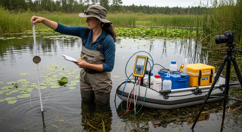
The standard methodology for permit applications and management planning is a quantitative point-intercept survey: the lake is divided into a grid, and plant samples are collected at predetermined stations throughout the water body. This produces species-specific distribution maps, frequency data, and (in some protocols) biomass estimates. For a small pond (1–5 acres), expect $800–$2,500. For a 10–50 acre lake, $2,000–$5,000. For a 50–200 acre lake, $4,000–$10,000. Data processing and report preparation are typically included in these estimates. Management frequency guide →
Annual Monitoring Survey
Once a baseline survey establishes the initial condition of a water body, subsequent annual monitoring surveys are typically less expensive — the surveyor can focus on areas identified in the baseline as containing target species, rather than surveying the entire water body from scratch. Annual monitoring surveys for small ponds typically run $400–$1,500; for larger lakes, $1,500–$4,000. Some lake managers combine annual monitoring with post-treatment assessment to reduce overall survey costs.
What Factors Affect Survey Cost?
Several factors drive cost variation beyond water body size: water clarity (clear water allows visual identification without sampling; turbid water requires more intensive rake sampling); depth (deeper water requires boat-based sampling, adding equipment time); species complexity (water bodies with many species take longer to survey accurately); accessibility (remote lakes with difficult boat launch access add time and cost); travel distance from the surveyor's home base; and report requirements (detailed GIS-based maps with species distribution polygons cost more than basic sketch maps).
How to Use Survey Results
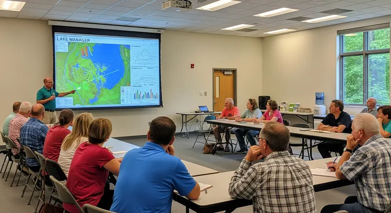
Survey results are the foundation for all management decisions and permit applications. Most states require a current survey (typically conducted within 1–3 years) as part of the herbicide permit application. The survey identifies target species that need treatment — allowing selection of the most effective and narrowly targeted herbicide products. It documents the pre-treatment condition needed to evaluate management effectiveness. And it reveals the presence of rare or protected native species that should be avoided in treatment planning. Investing in a professional survey before treatment typically saves money overall by preventing ineffective or misdirected treatment. Lake management plan guide →
Sources & Scientific References
- Madsen, J.D. (1999). Point intercept and line intercept methods for aquatic plant management. ERDC Technical Notes Collection. US Army Corps of Engineers.
- Aquatic Plant Management Society. (2022). Professional Development Handbook: Aquatic Vegetation Survey Methods. APMS.
- Nichols, S.A. (1999). Floristic quality assessment of Wisconsin lake plant communities with example applications. Lake and Reservoir Management, 15(3), 133–141.
Frequently Asked Questions
Why do I need a professional aquatic vegetation survey?
A professional survey is valuable for three reasons: it identifies what species are present — essential for selecting the correct management approach and avoiding harm to native species; it documents the baseline condition of the water body — required for measuring management effectiveness; and it is required by most state agencies as part of the permit application for aquatic herbicide treatment. Without accurate species identification, you risk treating the wrong plants with ineffective or harmful products.
What does a typical aquatic vegetation survey include?
A standard aquatic vegetation survey includes: boat-based and wading transect coverage of the entire water body; identification of all aquatic plant species present; mapping of species distribution and approximate coverage (percent cover or acres); notes on water depth, water clarity, and substrate; a written report with species list, maps, and management recommendations; and photographs of key species and representative habitat conditions. More detailed surveys may include point-intercept sampling, density estimates, and biomass sampling.
How often should a lake be surveyed?
Most lake managers recommend an initial baseline survey followed by annual or biennial monitoring surveys to track changes in weed populations over time. Annual surveys are most valuable during the first 2–3 years of a management program, when treatment response is being evaluated and adjustments are being made. Post-treatment surveys (4–6 weeks after herbicide treatment) assess treatment effectiveness and identify areas needing retreatment. State permit renewals often require evidence of current vegetation conditions.
Can I survey my own lake without hiring a professional?
Landowners with small private ponds can conduct basic vegetation inventories using identification guides and free online resources. However, accurate identification of many aquatic species — particularly submerged plants that look similar — requires training and experience. Misidentification can lead to ineffective treatment. For permit applications, most states require surveys conducted by licensed professionals. For management decisions involving herbicides, professional survey data is strongly recommended.
How do I find a qualified aquatic vegetation surveyor?
Qualified aquatic vegetation surveyors can be found through your state's department of natural resources (which often maintains lists of licensed aquatic plant managers), through the Aquatic Plant Management Society's professional directory, through university extension services, and through water quality consulting firms. For permit-required surveys, verify that the surveyor holds the appropriate state license for aquatic plant identification and management.
Key Takeaways
- A baseline aquatic vegetation survey by a professional typically costs $1,500–$8,000 depending on lake size and depth.
- Small ponds (under 5 acres) can often be surveyed for $500–$2,000; large lakes (100+ acres) may cost $10,000 or more.
- Annual monitoring surveys (tracking change from baseline) are typically less expensive than baseline surveys.
- Some state programs offer low-cost or subsidized surveys for priority invasive species — contact your state DNR.
- A professional survey is the essential first step before any herbicide treatment — required by most state permit applications.
Ten-Year Lake Management Plan: Lake Wingra, WI
Lake Wingra, a 342-acre urban lake in Madison, WI, developed a comprehensive 10-year management plan coordinating the City of Madison, University of Wisconsin, and adjacent neighborhood associations. The plan addressed Eurasian watermilfoil, curly-leaf pondweed, and purple loosestrife through an integrated approach including targeted herbicide treatment, mechanical harvesting, native plant restoration, and public education.
Key outcome: The structured multi-agency planning process secured consistent funding across multiple budget cycles, a key advantage over ad hoc management. Native plant restoration efforts showed measurable progress in designated restoration zones within three years of initiation.
We used the integrated management framework from this site to structure our Eurasian watermilfoil control program. After three seasons we've reduced lake-wide coverage by 78% on our 340-acre water body.
Susan Thibodeau Lake District Manager, MN · Crow Wing CountyThe seasonal timing guidance has been invaluable. Treating at the right growth stage cut our herbicide costs by nearly 30% without sacrificing efficacy on our county-managed reservoir.
Dale Buchanan County Parks Director, MI · Kalamazoo County